
From navigation to autonomous driving: maps in the mobility of tomorrow
In recent years, maps used by vehicles have become increasingly complex and are now periodically updated over-the-air; they are not only a useful tool for navigation, but a valuable basis for automated driving.
The importance of maps lies in the key data they contain, which are useful not only for the driver but also, and more importantly, for the vehicle. The most obvious function for users remains that of orientation and viewing points of interest, with navigation functions indicating which lane to take, where to turn, and how to get to the destination.
Thinking from the perspective of automated driving, a significant element is added to all this: localization within road lanes. This allows the car to define its exact location in relation to everything around itself, because maps also tell the vehicle what the road geometry looks like. Autonomous driving functions obviously require a great degree of precision. And what you see on the infotainment system display is merely a simplified user interface: when it comes to maps in terms of automated driving, the relevant data is not represented visually, but used directly by the vehicle for various driving functions.
Maps and sensors
In some respects, a map can be understood as a kind of sensor, as it helps the vehicle to understand and perceive its environment. But of course maps work in different ways to traditional sensors such as cameras and radar, and compared to those they hold a couple of key advantages.
Firstly, sensors have limited visual capacity and cannot look around corners. For example, if during an overtake, the overtaken vehicle covers a road sign with a speed limit, the vehicle sensor will not recognize it - the map, on the other hand, knows exactly where the car is, what the allowed speed is in that section, and also in subsequent sections. Secondly, sensor performance is influenced by both light and weather conditions like rain, snow, and fog - elements that instead have no influence on a map's data.
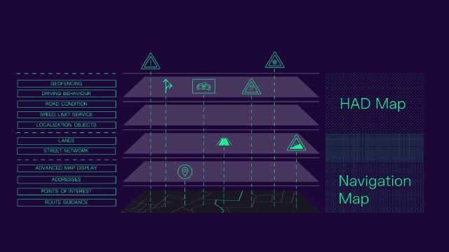
Multi-layer architecture
CARIAD - the Volkswagen Group's software company - uses all available information to improve driving safety and comfort. Following the principle of sensor diversity, all data provided by both maps and sensors is used to increase the reliability and accuracy of environmental perception.
Specifically, CARIAD is developing a solution called OneMap that will serve for both orientation and localization - a high-level architecture that features various layers. The simplest form, that is the first layer, is the standard-definition (SD) map, which contains all the fundamental information about roads. The high-definition (HD) map adds additional information, such as lane markings. The combination of these two maps forms the navigation map: it serves for orientation and contains information about the road network, provides the user with an advanced map view, which includes details about lanes, and integrates services like traffic information. Points of interest and addresses are proposed according to a hierarchical scheme.
Automated guidance
The top layer consists of maps for highly automated driving (HAD): the most precise, even and especially at the level of vehicle location. In addition to road network and lane data, which are more detailed and include information such as the localization of traffic signals, traffic lights and poles, they integrate speed limits, road conditions, and geofencing. The latter feature, in particular, tells the vehicle where autonomous driving is available and permitted.
HAD maps also contain data related to driving behavior: if, for example, there is a wall on the right side of the road, the vehicle will move slightly to the left from the middle of the lane, just as a human driver would do. This creates a more natural and comfortable experience for those behind the wheel.
OneMap
A significant advantage of OneMap is the consistency between the navigation and highly automated driving layers, which does not require the use of two separate maps as is usually the case. This gives users a uniform experience with the added benefit of more accurate directions while navigating.
Navigation which, as mentioned, is not the only function for which maps are used. They can be used also, for example, to support the battery in an electric car: they allow to optimize the range and to smartly plan possible charging stops based on route and driving behavior. As a fundamental prerequisite for automated driving, the OneMap architecture will be integrated on all Volkswagen Group vehicles.
Source: CARIAD
VGI | Responsible OU: VP | Creation date: article date | Class 9.1